HydraulicSaleve Node
Simulates hydraulic erosion using a stream power law on an adaptive triangulated mesh. The terrain is converted to a mesh, eroded through flow accumulation and slope-driven processes, then projected back to a heightmap. The main influencing parameters are 'Drainage Exponent' and 'Maximum Slope (Domain Center)', which drive most of the terrain shaping.
Category
Erosion/Hydraulic
Inputs
| Name | Type | Description |
|---|---|---|
| dx | VirtualArray | Displacement with respect to the domain size (x-direction). |
| dy | VirtualArray | Displacement with respect to the domain size (y-direction). |
| input | VirtualArray | No description |
| mask | VirtualArray | No description |
Outputs
| Name | Type | Description |
|---|---|---|
| output | VirtualArray | No description |
Parameters
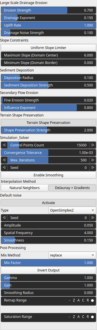
| Name | Type | Description |
|---|---|---|
| Control Points Count | Integer | Number of vertices in the adaptive triangulated mesh. Higher => more details, slower computation. |
| Deposition Radius | Float | Spatial extent where sediment is redistributed. Larger => smoother, more diffused deposition. |
| Activate | Bool | Enables or disables the built-in drainage noise. If an external noise input is provided, it overrides this default noise. |
| Spatial Frequency | Float | Base spatial frequencies in the X and Y directions. |
| Amplitude | Float | Noise amplitude. |
| Type | Enumeration | Noise type. |
| Seed | Random seed number | Random seed number. The random seed is an offset to the randomized process. A different seed will produce a new result. |
| Smoothness | Float | Controls the resulting smoothness of the fractal layering process. |
| Drainage Noise Strength | Float | Adds spatial perturbation to flow directions. Breaks symmetry and produces more natural, irregular drainage patterns. |
| Enable Smoothing | Bool | No description |
| Sediment Deposition Strength | Float | Amount of material deposited during erosion. Higher => more filling of valleys and flatter basins. |
| Shape Preservation Strength | Float | No description |
| Interpolation Method | Choice | No description |
| Drainage Exponent | Float | Controls how strongly water flow (drainage area) influences erosion. Higher values => channels concentrate more => sharper river networks. |
| Max. Iterations | Integer | Hard cap on simulation steps. |
| Gain | Float | Mid-centered gain transformation applied to the elevation values. This is a non-linear recurve operator centered around the mid elevation (typically 0.5). Increasing the gain pushes values toward the minimum and maximum elevations, creating flatter low/high regions with a steeper transition around the midpoint. |
| Gamma | Float | Standard gamma correction applied to the elevation values. This is a monotonic power-law remapping that shifts emphasis toward low or high elevations, making the overall shape sharper or bulkier without changing its ordering. |
| Invert Output | Bool | Inverts the output values after processing, flipping low and high values across the midrange. |
| Mix Factor | Float | Mixing factor for blending input and output values. A value of 0 uses only the input, 1 uses only the output, and intermediate values perform a linear interpolation. |
| Mix Method | Enumeration | Method used to combine input and output values. Options include linear interpolation (default), min, max, smooth min, smooth max, add, and subtract. |
| Remap Range | Value range | Linearly remaps the output values to a specified target range (default is [0, 1]). |
| Saturation Range | Value range | Modifies the amplitude of elevations by first clamping them to a given interval and then scaling them so that the restricted interval matches the original input range. This enhances contrast in elevation variations while maintaining overall structure. |
| Smoothing Radius | Float | Defines the radius for post-processing smoothing, determining the size of the neighborhood used to average local values and reduce high-frequency detail. A radius of 0 disables smoothing. |
| Terrain Shape Preservation | Bool | Modulates erosion resistance based on height. Typically preserves peaks and reduces flattening. |
| Seed | Random seed number | Random seed number. The random seed is an offset to the randomized process. A different seed will produce a new result. |
| Maximum Slope (Domain Center) | Float | Upper bound on slope in central regions. Prevents unrealistic steep gradients. |
| Minimum Slope (Domain Border) | Float | Upper bound on slope constraint near boundaries. Helps stabilize edges and avoid artifacts. |
| Influence Exponent | Float | Shapes how flow intensity affects fine erosion. Higher => more concentrated erosion. |
| Fine Erosion Strength | Float | Controls small-scale channel carving (secondary erosion). Enhances details like rills and small streams. |
| Erosion Strength | Float | Blend factor between original terrain and eroded result. Low => subtle erosion, High => fully eroded terrain. |
| Convergence Tolerance | Float | Threshold for stopping iterations. Lower => more precise but slower convergence. |
| Uniform Slope Limiter | Bool | If enabled, uses a single slope limit everywhere. Otherwise, slope varies spatially (center vs borders). |
| Uplift Rate | Float | Constant terrain elevation increase per iteration. Competes with erosion => defines long-term mountain vs valley balance. |
Example
No example yet
No example available for this node.