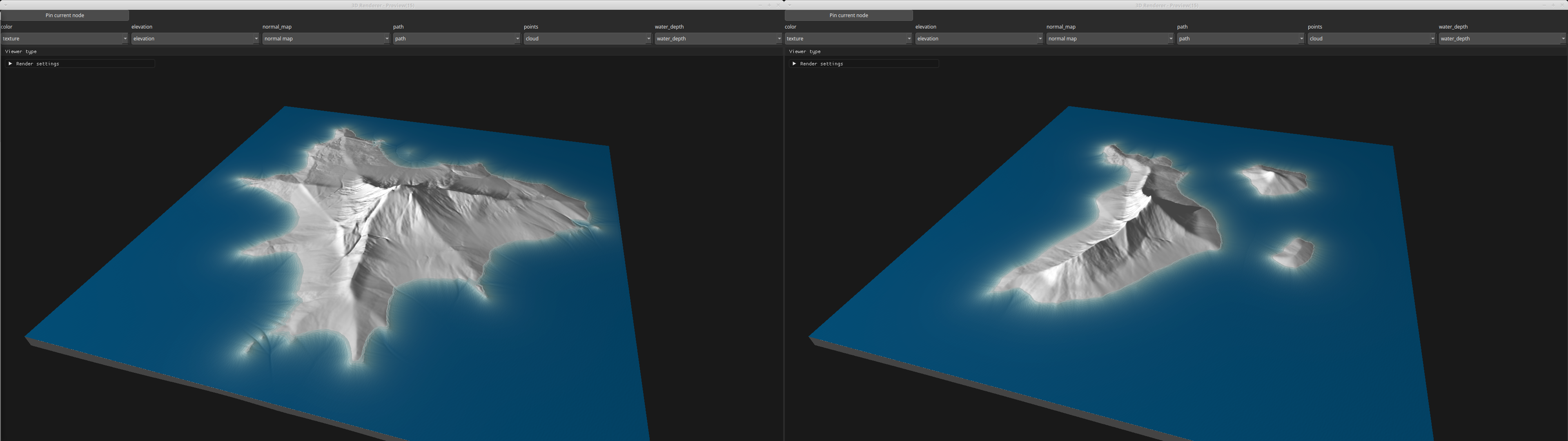
Island Node
This function generates a procedural island heightmap from a binary land mask by combining a distance-based radial profile with fractal noise modulation.
Category
Primitive/Geological
Inputs
| Name | Type | Description |
|---|---|---|
| dr | VirtualArray | Input radial noise. Optional, if not set, the embedded default noise generator is used. |
| land_mask | VirtualArray | Binary mask defining the island’s footprint; nonzero pixels are considered land. Consider using the node IslandLandMask to generate this mask. |
Outputs
| Name | Type | Description |
|---|---|---|
| inland_mask | VirtualArray | Output buffer receiving a mask of inland pixels (non-coastal land). |
| out | VirtualArray | No description |
| water_depth | VirtualArray | Output water depth map representing flooded areas. |
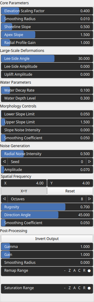
Parameters
| Name | Type | Description |
|---|---|---|
| Elevation Scaling Factor | Float | Global elevation scale. |
| Smoothing Radius | Float | Radius of the smoothing filter applied to the distance transform with respect to a unit domain. |
| Smoothing Coefficient | Float | Smoothing factor applied to the final radial profile for continuity. |
| Lee-Side Amplitude | Float | Strength of lee-side erosion. |
| Lee-Side Angle | Float | Direction (angle) used to compute lee-side erosion. |
| Amplitude | Float | Overall amplitude of the noise added to the terrain surface. |
| Direction Angle | Float | Rotation angle of the noise field, allowing oriented terrain features. |
| Smoothing Coefficient | Float | Smoothing factor. |
| Spatial Frequency | Wavenumber | Base spatial frequencies in the X and Y directions. |
| Octaves | Integer | Number of FBM layers used to build the noise (more octaves means more detail). |
| Rugosity | Float | Persistence-like factor controlling roughness decay between FBM octaves. |
| Gain | Float | Mid-centered gain transformation applied to the elevation values. This is a non-linear recurve operator centered around the mid elevation (typically 0.5). Increasing the gain pushes values toward the minimum and maximum elevations, creating flatter low/high regions with a steeper transition around the midpoint. |
| Gamma | Float | Standard gamma correction applied to the elevation values. This is a monotonic power-law remapping that shifts emphasis toward low or high elevations, making the overall shape sharper or bulkier without changing its ordering. |
| Invert Output | Bool | Inverts the output values after processing, flipping low and high values across the midrange. |
| Remap Range | Value range | Linearly remaps the output values to a specified target range (default is [0, 1]). |
| Saturation Range | Value range | Modifies the amplitude of elevations by first clamping them to a given interval and then scaling them so that the restricted interval matches the original input range. This enhances contrast in elevation variations while maintaining overall structure. |
| Smoothing Radius | Float | Defines the radius for post-processing smoothing, determining the size of the neighborhood used to average local values and reduce high-frequency detail. A radius of 0 disables smoothing. |
| Radial Noise Intensity | Float | Strength of radial displacement noise applied to deform the island outline. |
| Radial Profile Gain | Float | Exponent controlling how quickly elevation falls off from center to shore. |
| Seed | Random seed number | Random seed number. The random seed is an offset to the randomized process. A different seed will produce a new result. |
| Apex Slope | Float | Slope at the summit. |
| Upper Slope Limit | Float | Maximum slope value allowed in the radial profile. |
| Lower Slope Limit | Float | Minimum slope value used in shaping the radial profile. |
| Slope Noise Intensity | Float | Amount of noise applied to locally vary the slope and break uniform gradients. |
| Shoreline Slope | Float | Slope at the shoreline. |
| Uplift Amplitude | Float | Amplitude of uplift deformation. |
| Water Decay Rate | Float | Water depth decay with the distance to the shoreline. |
| Water Depth Level | Float | Maximum deth of water. |
Example
Corresponding Hesiod file: Island.hsd. Use [Ctrl+I] in the node editor to import a hsd file within your current project.
Note
Example files are kept up-to-date with the latest version of Hesiod. If you find an error, please open an issue.
Screenshots